- −12%


Go explore the outdoors.

Go explore the outdoors.

SPEDIZIONE GRATUITA IN ITALIA DA 99 EURO*

CHECKOUT SICURO AL 100%

N.1 in Italia
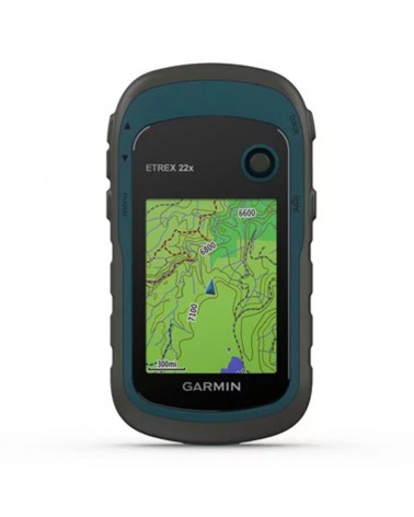
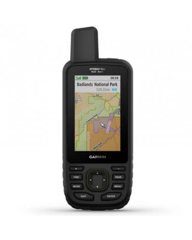
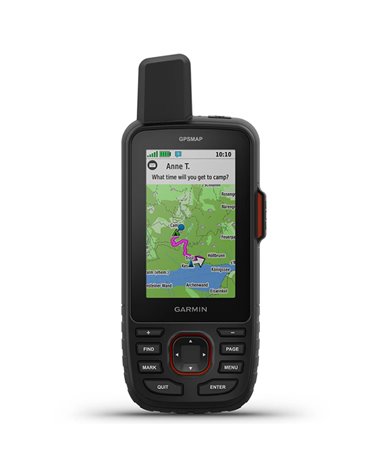
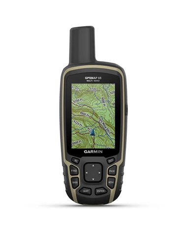
Make more time for adventure with this premium, rugged handheld. Get long battery life and multi-band technology for enhanced accuracy plus preloaded TopoActive maps and access to satellite imagery.
• See your route clearly on the 3″ sunlight-readable colour display.
• Travel longer with up to 180 hours of battery life in tracking mode and up to 840 hours in expedition mode.
• Track your position in challenging conditions with multi-band technology and expanded GNSS support.
• See the terrain you’ll travel with vivid satellite imagery that downloads right to your handheld GPS.
• Stay tuned to the forecast with active weather on your route when paired to your compatible smartphone.
SPECS
General
DIMENSION: 6.2 x 16.3 x 3.5 cm (2.5″ x 6.4″ x 1.4″)
DISPLAY SIZE: 3.8 x 6.3 cm (1.5″W x 2.5″H ); 7.6 cm diag (3″)
DISPLAY RESOLUTION: 240 x 400 pixels
DISPLAY TYPE: Transflective colour TFT
WEIGHT: 230 g with batteries
WATER RATING: IPX7
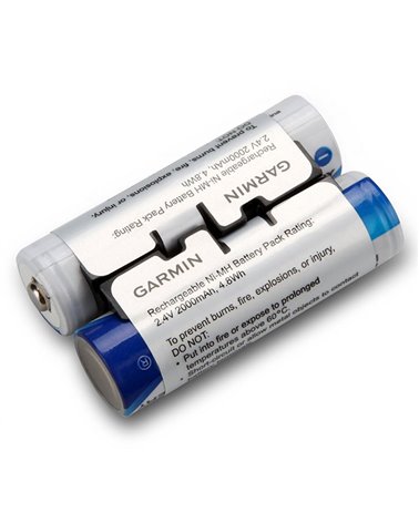
BATTERY TYPE: Rechargeable, internal lithium-ion
BATTERY LIFE: Up to 180 hours in default mode - Up to 840 hours in expedition mode
MIL-STD-810: Yes (thermal, shock, water); bare unit only
INTERFACE: USB-C
MEMORY/HISTORY: 16 GB (user space varies based on included mapping)
Maps & memory
PRELOADED MAPS: Yes (TopoActive Europe; routable)
ABILITY TO ADD MAPS: Yes
BASEMAP: Yes
AUTOMATIC ROUTING (TURN BY TURN ROUTING ON ROADS) FOR OUTDOOR ACTIVITIES: Yes
MAP SEGMENTS: 15,000
SATELLITE IMAGERY: Yes (direct to device)
INCLUDES DETAILED HYDROGRAPHIC FEATURES (COASTLINES, LAKE/RIVER SHORELINES, WETLANDS AND PERENNIAL AND SEASONAL STREAMS): Yes
INCLUDES SEARCHABLE POINTS OF INTERESTS (PARKS, CAMPGROUNDS, SCENIC LOOKOUTS AND PICNIC SITES): Yes
DISPLAYS NATIONAL, STATE AND LOCAL PARKS, FORESTS, AND WILDERNESS AREAS: Yes
STORAGE AND POWER CAPACITY: Yes (32 GB max microSD™ card)
WAYPOINTS/FAVOURITES/LOCATIONS: 10,000
COURSES: 250, 200 course points per course
TRACKS: 250
NAVIGATION TRACK LOG: 20,000 points, 250 saved gpx tracks, 300 saved fit activities
ACTIVITIES: Yes
NAVIGATION ROUTES: 250, 250 points per route; 50 points auto routing
Sensors
HIGH-SENSITIVITY RECEIVER: Yes
GPS: Yes
GLONASS: Yes
GALILEO: Yes
QZSS: Yes
BEIDOU: Yes
IRNSS : Yes
BAROMETRIC ALTIMETER: Yes
COMPASS: Yes (tilt-compensated 3-axis)
GPS COMPASS (WHILE MOVING): Yes
MULTI-BAND FREQUENCY: Yes
Daily smart features
CONNECT IQ™ (DOWNLOADABLE WATCH FACES, DATA FIELDS, WIDGETS AND APPS): Yes
SMART NOTIFICATIONS ON HANDHELD: Yes
VIRB® CAMERA REMOTE: Yes
COMPATIBLE WITH GARMIN CONNECT™ MOBILE: Yes
ACTIVE WEATHER: Yes
Safety and tracking features
LIVETRACK: Yes
Outdoor recreation
POINT-TO-POINT NAVIGATION: Yes
TRACBACK®: Yes
AREA CALCULATION: Yes
HUNT/FISH CALENDAR: Yes
SUN AND MOON INFORMATION: Yes
XERO™ LOCATIONS: Yes
GEOCACHING-FRIENDLY: Yes (Geocache Live)
CUSTOM MAPS COMPATIBLE: Yes (500 custom map tiles)
PICTURE VIEWER: Yes
LED BEACON FLASHLIGHT: Yes
inReach® features
INREACH REMOTE COMPATIBLE: Yes
Outdoor applications
COMPATIBLE WITH GARMIN EXPLORE™ APP: Yes
GARMIN EXPLORE WEBSITE COMPATIBLE: Yes
Connections
CONNECTIONS WIRELESS CONNECTIVITY: Yes (Wi-Fi®, Bluetooth®, ANT+®)
IN THE BOX
GPSMAP 67
Type A to Type C USB cable
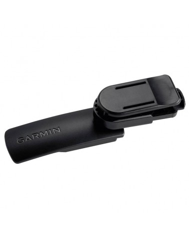
Carabiner clip
Documentation
Datablad